
What a VicPlan report tells you before you engage an architect - and why most people skip it
- jarrydsnelling
- 6 days ago
- 4 min read

What a VicPlan report tells you before you engage an architect — and why most people skip it
Most residential projects in Victoria start the same way. A homeowner finds an architect they like, signs a fee proposal, and design begins. The site gets measured eventually. The planning framework gets discovered during the permit process. Surprises surface when they're expensive to fix.
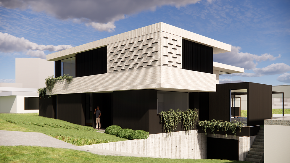
On the Silvan House project — a new custom home on 10.8 hectares in the Yarra Ranges foothills — we did it in the opposite order. Before Steve and Courtney signed anything, before any fee was committed, there was a 30-page Information Gathering report covering every planning control on the property, the full site constraints, the brief, and the complete consultant sequence required to get from pre-design to construction. That report was the basis for their decision to proceed. They could see exactly what this project involved before they committed to anything.
That's how it should work on every project.
What most people do
The standard approach is to engage an architect, agree a fee, and start drawing. The survey happens when it's needed. The planning research happens when the permit application is being prepared. Overlays — the additional layers of planning rules that sit on top of the base zone — get discovered when the planning officer asks questions the design can't answer.
On a suburban block with straightforward zoning this sequence produces inconvenience. On a rural property with multiple overlays it produces redesigns, delays, and cost blowouts that were entirely avoidable.
The Silvan site carries five confirmed overlays — Bushfire Management, Erosion Management Schedule 3 specifically for landslip susceptibility, Environmental Significance Schedule 1 for highest biodiversity habitat, Significant Landscape Schedule 5 for the red soil intensive agriculture landscape, and Designated Bushfire Prone Area. Each one adds specific requirements to what the design has to demonstrate before a planning permit can be granted.
None of these are obscure. All of them are on VicPlan — the Victorian government's free planning database — available to anyone before a single conversation with an architect begins.
Why it matters
The Erosion Management Overlay Schedule 3 on this site has an expiry provision. Its requirements, including a mandatory geotechnical assessment of the ground conditions and landslip risk, cease to have effect after 7 October 2027. An application lodged before that date faces the current provisions in full. An application lodged after that date may face a different framework. That's 18 months from now on the current programme — achievable, but only if every stage moves efficiently.
The Environmental Significance Overlay applies a 30-metre setback from Ferndale Creek, which runs along the road boundary. That line — confirmed on the feature and level survey — rules out certain siting positions near the road boundary entirely. A design that ignored it would need to be relocated before the planning application could proceed.
The bushfire overlay means a Bushfire Management Statement is mandatory before any permit can be granted. The BAL rating — Bushfire Attack Level, the measure of how much fire risk the building is exposed to based on where it sits on the land — gets determined by a bushfire consultant once the dwelling location is confirmed. In the Silvan area, BAL ratings commonly run from BAL-12.5 at the lower end through to BAL-40. The construction cost difference between those two outcomes on a large home with extensive glazing runs to tens of thousands of dollars. Where the building sits on the land — a pre-design decision — is the most cost-effective way to manage that.
None of these constraints prevent the project. All of them define how it has to be approached. And all of them were understood before a sketch was drawn.
What to do instead
Before engaging an architect on any Victorian property — residential or rural — run a VicPlan report. It takes five minutes and costs nothing. Search the property address at vicplan.com.au. Note the zone and every overlay. Each overlay has a schedule attached — that's the specific version of the overlay that applies to your property. The schedule is what tells you exactly what the design has to demonstrate.
Then ask your architect whether they have read those overlays and their schedules before preparing a fee proposal. A fee proposal prepared without that research is a fee proposal prepared without knowing what the project actually involves.
The feasibility work on the Silvan project — the 30-page report, the overlay research, the site analysis — was completed before Steve and Courtney signed anything. It told them what the site allows. Combined with their completed client questionnaire and brief, it formed the full design scope — the complete picture of what this project is trying to achieve and what it has to work within simultaneously. Design began from that position. Not from assumption.
The survey, the consultant sequence, the planning framework — all of it understood before the first sketch. That sequence is not a premium service. It's the correct order of operations for any residential project in Victoria.
The slope on this Silvan site faces north-northwest. The views and the solar access point in exactly the same direction. The planning overlays define the constraints. The brief defines the ambition. When both are understood before design begins, the first sketch can be the right one — not a starting point that gets revised when the surprises arrive.

Comments